


JC 58 Fontainebleau, le sentier des carriers

Les 1000 pattes
Club randonnées SERVON
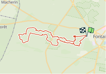

Length
17.5 km

Max alt
141 m

Uphill gradient
303 m
Km-Effort
22 km

Min alt
81 m

Downhill gradient
303 m
Boucle
Yes
Creation date :
2022-02-15 07:57:27.058
Updated on :
2025-03-22 14:12:32.262
4h53
Difficulty : Medium

FREE GPS app for hiking
 SityTrail
IGN / Geographical institutes
SityTrail Plus
The world is yours!
About
Trail On foot of 17.5 km to be discovered at Ile-de-France, Seine-et-Marne, Fontainebleau. This trail is proposed by Les 1000 pattes.
Description
Parking La Faisanderie ONF à Fontainebleau
Trajet Servon-->Parking (41km :47mn)

Positioning
Country:
France
Region :
Ile-de-France
Department/Province :
Seine-et-Marne
Municipality :
Fontainebleau
Location:
Unknown
Start:(Dec)
Start:(UTM)
476161 ; 5361314 (31U) N.
Comments