


Pompignan noir de Monnier

JMJ42
User
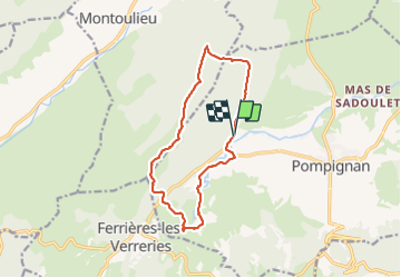

Length
13.4 km

Max alt
465 m

Uphill gradient
358 m
Km-Effort
18.2 km

Min alt
198 m

Downhill gradient
364 m
Boucle
Yes
Creation date :
2022-02-15 08:37:08.548
Updated on :
2022-02-15 13:54:07.716
3h47
Difficulty : Easy

FREE GPS app for hiking
 SityTrail
IGN / Geographical institutes
SityTrail Plus
The world is yours!
About
Trail Walking of 13.4 km to be discovered at Occitania, Gard, Pompignan. This trail is proposed by JMJ42.
Positioning
Country:
France
Region :
Occitania
Department/Province :
Gard
Municipality :
Pompignan
Location:
Unknown
Start:(Dec)
Start:(UTM)
566397 ; 4861142 (31T) N.
Comments