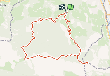
18.2 km | 30 km-effort
tour du castelmouly
Martinet.Claude
User
Length
12.7 km
Max alt
1177 m
Uphill gradient
554 m
Km-Effort
20 km
Min alt
680 m
Downhill gradient
558 m
Boucle
Yes
Creation date :
2019-03-14 17:27:47.407
Updated on :
2019-03-14 17:27:47.446
4h03
Difficulty : Easy
FREE GPS app for hiking
About
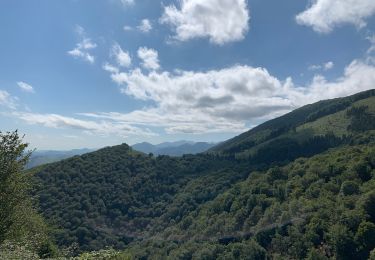
Trail Walking of 12.7 km to be discovered at Occitania, Hautespyrenees, Bagnères-de-Bigorre. This trail is proposed by Martinet.Claude.
Description
grand tour croix de manse
Positioning
Country:
France
Region :
Occitania
Department/Province :
Hautespyrenees
Municipality :
Bagnères-de-Bigorre
Location:
Unknown
Start:(Dec)
Start:(UTM)
266665 ; 4770879 (31T) N.
Comments
Trails nearby
FEU 2015 - Etape 5
Walking
Easy
(1)
Bagnères-de-Bigorre,
Occitania,
Hautespyrenees,
France
6h 29min
No
Casque du Lheris
Walking
Medium
Gerde,
Occitania,
Hautespyrenees,
France
16.8 km | 28 km-effort
6h 25min
Yes
hourquette
Road bike
Very difficult
(1)
Beaudéan,
Occitania,
Hautespyrenees,
France
50 km | 65 km-effort
2h 54min
Yes
Randonnée 1 mai haut de Bagneres
Mountain bike
Very difficult
Bagnères-de-Bigorre,
Occitania,
Hautespyrenees,
France
28 km | 38 km-effort
3h 18min
Yes
Le Tour de la Bouche - Campan
Walking
Difficult
Campan,
Occitania,
Hautespyrenees,
France
15.2 km | 28 km-effort
7h 0min
Yes
Casque du Lhéris - Gerde
Walking
Medium
Gerde,
Occitania,
Hautespyrenees,
France
14.1 km | 24 km-effort
5h 0min
Yes
2023 09 23 CHEMIN du PIÉMONT PYRÉNÉEN - 16ème étape : Bagnères de Bigorre - L...
Walking
Medium
Bagnères-de-Bigorre,
Occitania,
Hautespyrenees,
France
25 km | 32 km-effort
4h 39min
No
Col des Palomieres et Pic de Castets
Walking
Medium
Gerde,
Occitania,
Hautespyrenees,
France
5.2 km | 8.2 km-effort
1h 40min
Yes
Randonnée autour de Pouzac
Walking
Difficult
Pouzac,
Occitania,
Hautespyrenees,
France
9.2 km | 13.7 km-effort
2h 51min
Yes
Merci.
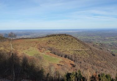
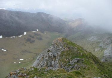
Belle rando, tracé facile à suivre, avec des paysages magnifiques.