Sentier de la Vieille Chopine
SityTrail - itinéraires balisés pédestres
Tous les sentiers balisés d’Europe PRO
Length
14.8 km
Max alt
492 m
Uphill gradient
313 m
Km-Effort
19.1 km
Min alt
333 m
Downhill gradient
324 m
Boucle
Yes
Signpost
Creation date :
2022-02-15 14:34:02.97
Updated on :
2022-03-02 16:20:41.597
4h19
Difficulty : Easy
FREE GPS app for hiking
About
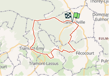
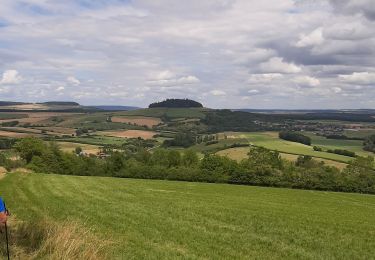
Trail On foot of 14.8 km to be discovered at Grand Est, Meurthe-et-Moselle, Vandeléville. This trail is proposed by SityTrail - itinéraires balisés pédestres.
Description
Trail created by Association intercommunale des Sentiers de la Mirabelle.
Positioning
Country:
France
Region :
Grand Est
Department/Province :
Meurthe-et-Moselle
Municipality :
Vandeléville
Location:
Unknown
Start:(Dec)
Start:(UTM)
721446 ; 5368128 (31U) N.
Comments
Trails nearby
Circuit du Brénon
On foot
Easy
Tramont-Lassus,
Grand Est,
Meurthe-et-Moselle,
France
7.8 km | 10.2 km-effort
2h 18min
No
Circuit Barrès - Brunehaut
On foot
Easy
Vaudémont,
Grand Est,
Meurthe-et-Moselle,
France
8.4 km | 10.7 km-effort
2h 26min
Yes
Circuit Le Vallon de Jolivie
On foot
Easy
Favières,
Grand Est,
Meurthe-et-Moselle,
France
12.1 km | 14.8 km-effort
3h 21min
Yes
Favieres
Nordic walking
Medium
Favières,
Grand Est,
Meurthe-et-Moselle,
France
13 km | 16.6 km-effort
3h 36min
Yes
Favieres 2ème jours
Horseback riding
Medium
Favières,
Grand Est,
Meurthe-et-Moselle,
France
21 km | 25 km-effort
3h 9min
Yes
Saxon-Sion 12 300m + 282m (théorique)
Walking
Difficult
Vaudémont,
Grand Est,
Meurthe-et-Moselle,
France
12.2 km | 16 km-effort
3h 38min
Yes
Reco Favieres
Walking
Medium
Favières,
Grand Est,
Meurthe-et-Moselle,
France
14.2 km | 17.3 km-effort
3h 47min
Yes
marche du 28 09
Walking
Easy
Favières,
Grand Est,
Meurthe-et-Moselle,
France
10 km | 11.9 km-effort
2h 1min
Yes
favieres
Equestrian
Easy
Favières,
Grand Est,
Meurthe-et-Moselle,
France
19.2 km | 24 km-effort
3h 45min
No