


Ostschweiz

My Switzerland
Optez pour le retour à la nature GUIDE+

Length
260 km

Max alt
1304 m

Uphill gradient
5458 m
Km-Effort
333 km

Min alt
386 m

Downhill gradient
5461 m
Boucle
Yes
Creation date :
2014-12-10 00:00:00.0
Updated on :
2014-12-10 00:00:00.0
67h29
Difficulty : Unknown

FREE GPS app for hiking
 SityTrail
IGN / Geographical institutes
SityTrail Plus
The world is yours!
About
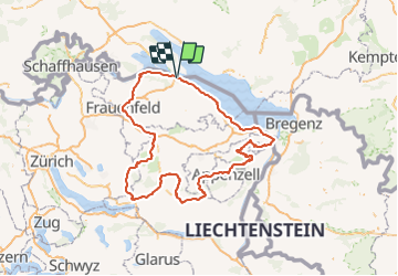
Trail Walking of 260 km to be discovered at Thurgau, Bezirk Kreuzlingen, Kreuzlingen. This trail is proposed by My Switzerland.
Positioning
Country:
Switzerland
Region :
Thurgau
Department/Province :
Bezirk Kreuzlingen
Municipality :
Kreuzlingen
Location:
Unknown
Start:(Dec)
Start:(UTM)
512571 ; 5277723 (32T) N.
Comments