


IT-COD

SityTrail - itinéraires balisés pédestres
Tous les sentiers balisés d’Europe GUIDE+
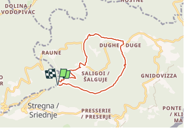

Length
6.4 km

Max alt
647 m

Uphill gradient
375 m
Km-Effort
11.4 km

Min alt
265 m

Downhill gradient
377 m
Boucle
Yes

Signpost
Creation date :
2022-02-15 16:26:49.902
Updated on :
2022-03-01 18:12:48.279
2h34
Difficulty : Easy

FREE GPS app for hiking
 SityTrail
IGN / Geographical institutes
SityTrail Plus
The world is yours!
About
Trail On foot of 6.4 km to be discovered at Friuli Venezia Giulia, Unknown, Stregna. This trail is proposed by SityTrail - itinéraires balisés pédestres.
Description
Trail created by Comune di Stregna.
Positioning
Country:
Italy
Region :
Friuli Venezia Giulia
Department/Province :
Unknown
Municipality :
Stregna
Location:
Unknown
Start:(Dec)
Start:(UTM)
390511 ; 5109775 (33T) N.
Comments