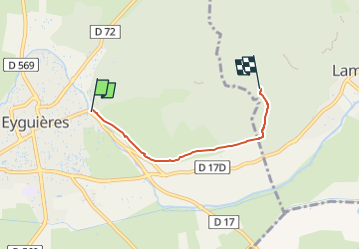
Trail On foot Eyguières - Circuit du Défens - Photo

Tous les sentiers balisés d’Europe GUIDE+

© OpenStreetMap contributors
Length
Length
3.5 km
Max alt
Max alt
247 m
Uphill gradient
Uphill gradient
151 m
Km-Effort
Km-Effort  
5 km
Min alt
Min alt
107 m
Downhill gradient
Downhill gradient
14 m
Boucle
Boucle
No
Signpost
Signpost
Creation date :
2022-02-15 17:22:02.986
Updated on :
2022-03-02 19:18:49.74

(0 Reviews)

On foot
On foot
1h08
Difficulty : Easy

Scan this QR Code to open this trail in the SityTrail application

FREE GPS app for hiking

Logo SityTrail SityTrail

IGN / Geographical institutes

Download SityTrail from the App Store Download SityTrail from Google Play

Logo SityTrail SityTrail Plus

The world is yours!

Download SityTrail from the App Store Download SityTrail from Google Play Download SityTrail on Huawei AppGallery

About

Trail On foot of 3.5 km to be discovered at Provence-Alpes-Côte d'Azur, Bouches-du-Rhône, Eyguières. This trail is proposed by SityTrail - itinéraires balisés pédestres.

Description

Télécharger les différents documents à votre disposition : guides touristiques, plus beaux itinéraires, circuit VTT et balades vélos …

Website: https://www.myprovence.fr/document/itineraires-de-randonnees/20-topo-rando-aplilles-lamanon_eyguieres_2016-ok-acces.pdf

Elevation profile

Positioning

Country:
France
Region :
Provence-Alpes-Côte d'Azur
Department/Province :
Bouches-du-Rhône
Municipality :
Eyguières
Location:
Unknown
Start:(UTM)
664341 ; 4840179 (31T) N.


Close
My subscriptions