


Via Ellenica Ostuni

SityTrail - itinéraires balisés pédestres
Tous les sentiers balisés d’Europe GUIDE+
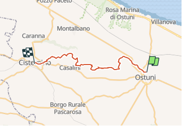

Length
19.9 km

Max alt
398 m

Uphill gradient
472 m
Km-Effort
26 km

Min alt
127 m

Downhill gradient
286 m
Boucle
No

Signpost
Creation date :
2022-02-15 18:30:06.894
Updated on :
2022-03-01 23:06:57.979
5h48
Difficulty : Medium

FREE GPS app for hiking
 SityTrail
IGN / Geographical institutes
SityTrail Plus
The world is yours!
About
Trail On foot of 19.9 km to be discovered at Apulia, Brindisi, Ostuni. This trail is proposed by SityTrail - itinéraires balisés pédestres.
Photos


Positioning
Country:
Italy
Region :
Apulia
Department/Province :
Brindisi
Municipality :
Ostuni
Location:
Unknown
Start:(Dec)
Start:(UTM)
717713 ; 4512251 (33T) N.
Comments