


Bergstation Sareis - Nenzinger Himmel (A)

SityTrail - itinéraires balisés pédestres
Tous les sentiers balisés d’Europe GUIDE+
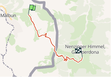

Length
4.8 km

Max alt
1994 m

Uphill gradient
47 m
Km-Effort
7.4 km

Min alt
1361 m

Downhill gradient
665 m
Boucle
No

Signpost
Creation date :
2022-02-16 16:43:02.545
Updated on :
2022-02-16 16:43:02.545
1h41
Difficulty : Easy

FREE GPS app for hiking
 SityTrail
IGN / Geographical institutes
SityTrail Plus
The world is yours!
About
Trail On foot of 4.8 km to be discovered at Unknown, Oberland, Triesenberg. This trail is proposed by SityTrail - itinéraires balisés pédestres.
Positioning
Country:
Liechtenstein
Region :
Unknown
Department/Province :
Oberland
Municipality :
Triesenberg
Location:
Unknown
Start:(Dec)
Start:(UTM)
547020 ; 5216785 (32T) N.
Comments