


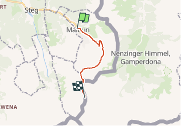
Malbun - Augstenberg - Pfaelzerhuette

SityTrail - itinéraires balisés pédestres
Tous les sentiers balisés d’Europe GUIDE+

Length
6.2 km

Max alt
2350 m

Uphill gradient
756 m
Km-Effort
14.6 km

Min alt
1600 m

Downhill gradient
255 m
Boucle
No

Signpost
Creation date :
2022-02-16 16:43:23.689
Updated on :
2022-02-16 16:43:23.689
3h19
Difficulty : Easy

FREE GPS app for hiking
 SityTrail
IGN / Geographical institutes
SityTrail Plus
The world is yours!
About
Trail On foot of 6.2 km to be discovered at Unknown, Oberland, Triesenberg. This trail is proposed by SityTrail - itinéraires balisés pédestres.
Positioning
Country:
Liechtenstein
Region :
Unknown
Department/Province :
Oberland
Municipality :
Triesenberg
Location:
Unknown
Start:(Dec)
Start:(UTM)
546117 ; 5216774 (32T) N.
Comments