Trail On foot Geinberg - Innviertel Runde - Photo

Tous les sentiers balisés d’Europe PRO

© OpenStreetMap contributors
Length
Length
3.2 km
Max alt
Max alt
462 m
Uphill gradient
Uphill gradient
88 m
Km-Effort
Km-Effort  
4.4 km
Min alt
Min alt
386 m
Downhill gradient
Downhill gradient
87 m
Boucle
Boucle
Yes
Signpost
Signpost
Creation date :
2022-02-16 17:03:24.968
Updated on :
2022-03-03 15:55:57.172

(0 Reviews)

On foot
On foot
59m
Difficulty : Easy

Scan this QR Code to open this trail in the SityTrail application

FREE GPS app for hiking

Logo SityTrail SityTrail

IGN / Geographical institutes

Download SityTrail from the App Store Download SityTrail from Google Play

Logo SityTrail SityTrail World

The world is yours!

Download SityTrail from the App Store Download SityTrail from Google Play Download SityTrail on Huawei AppGallery

About

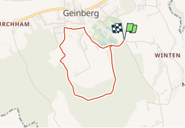
Trail On foot of 3.2 km to be discovered at Upper Austria, Bezirk Ried im Innkreis, Geinberg. This trail is proposed by SityTrail - itinéraires balisés pédestres.

Description

Trail created by Innviertel Tourismus.

Routenfarbe ist eigentlich dunkelblau, zur Unterscheidung mit der hellblauen 3er Runde habe ich die Farbe auf black/blue_pointer gesetzt

Photos

Positioning

Country:
Austria
Region :
Upper Austria
Department/Province :
Bezirk Ried im Innkreis
Municipality :
Geinberg
Location:
Unknown
Start:(UTM)
373837 ; 5346754 (33U) N.

Trails nearby

Trail On foot Geinberg - Schlanke Linie Runde - Photo
On foot
PRO

On foot

Easy
Geinberg, Upper Austria, Bezirk Ried im Innkreis, Austria
6.3 km | 7.8 km-effort
1h 46min
Yes
Trail On foot Geinberg - Lagerhaus Runde - Photo
On foot
PRO

On foot

Easy
Geinberg, Upper Austria, Bezirk Ried im Innkreis, Austria
9.5 km | 11.1 km-effort
2h 31min
Yes
Trail On foot Geinberg - Thermenlauf - Photo
On foot
PRO

On foot

Easy
Geinberg, Upper Austria, Bezirk Ried im Innkreis, Austria
10 km | 12.4 km-effort
2h 49min
Yes


Close
My subscriptions