


Gaillon/Montient -Les bois de jambville

Fky78
User
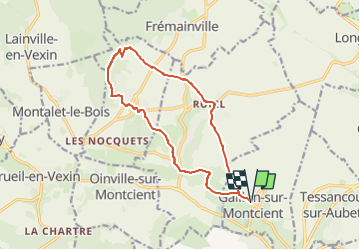

Length
13 km

Max alt
196 m

Uphill gradient
272 m
Km-Effort
16.6 km

Min alt
37 m

Downhill gradient
272 m
Boucle
Yes
Creation date :
2022-02-17 10:51:08.567
Updated on :
2024-03-15 22:33:52.71
3h46
Difficulty : Difficult

FREE GPS app for hiking
 SityTrail
IGN / Geographical institutes
SityTrail Plus
The world is yours!
About
Trail Walking of 13 km to be discovered at Ile-de-France, Yvelines, Gaillon-sur-Montcient. This trail is proposed by Fky78.
Positioning
Country:
France
Region :
Ile-de-France
Department/Province :
Yvelines
Municipality :
Gaillon-sur-Montcient
Location:
Unknown
Start:(Dec)
Start:(UTM)
418978 ; 5430867 (31U) N.
Comments