


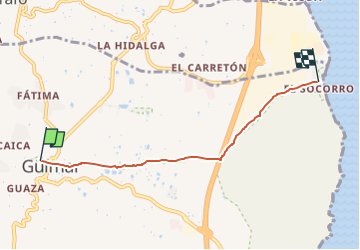
Camino del Socorro

SityTrail - itinéraires balisés pédestres
Tous les sentiers balisés d’Europe GUIDE+

Length
5.4 km

Max alt
289 m

Uphill gradient
0 m
Km-Effort
6.3 km

Min alt
12 m

Downhill gradient
274 m
Boucle
No

Signpost
Creation date :
2022-02-17 10:59:07.423
Updated on :
2022-02-17 10:59:07.423
1h25
Difficulty : Easy

FREE GPS app for hiking
 SityTrail
IGN / Geographical institutes
SityTrail Plus
The world is yours!
About
Trail On foot of 5.4 km to be discovered at Canary Islands, Santa Cruz de Tenerife, Güímar. This trail is proposed by SityTrail - itinéraires balisés pédestres.
Description
The Way is signposted annually
Photos


Positioning
Country:
Spain
Region :
Canary Islands
Department/Province :
Santa Cruz de Tenerife
Municipality :
Güímar
Location:
Unknown
Start:(Dec)
Start:(UTM)
361593 ; 3132997 (28R) N.
Comments