


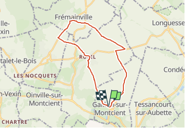
Boucle par Fremainville

Fky78
User

Length
12.8 km

Max alt
125 m

Uphill gradient
170 m
Km-Effort
15.1 km

Min alt
49 m

Downhill gradient
162 m
Boucle
Yes
Creation date :
2022-02-17 12:18:05.793
Updated on :
2024-03-15 22:29:31.346
3h25
Difficulty : Easy

FREE GPS app for hiking
 SityTrail
IGN / Geographical institutes
SityTrail Plus
The world is yours!
About
Trail On foot of 12.8 km to be discovered at Ile-de-France, Yvelines, Gaillon-sur-Montcient. This trail is proposed by Fky78.
Positioning
Country:
France
Region :
Ile-de-France
Department/Province :
Yvelines
Municipality :
Gaillon-sur-Montcient
Location:
Unknown
Start:(Dec)
Start:(UTM)
418974 ; 5430871 (31U) N.
Comments