


sennecey le gd- la chapelle de brancion

XavierFaidix
User
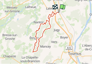

Length
30 km

Max alt
443 m

Uphill gradient
814 m
Km-Effort
41 km

Min alt
210 m

Downhill gradient
815 m
Boucle
Yes
Creation date :
2022-02-17 12:18:54.457
Updated on :
2022-02-18 14:15:33.279
3h40
Difficulty : Difficult

FREE GPS app for hiking
 SityTrail
IGN / Geographical institutes
SityTrail Plus
The world is yours!
About
Trail Mountain bike of 30 km to be discovered at Bourgogne-Franche-Comté, Saône-et-Loire, Sennecey-le-Grand. This trail is proposed by XavierFaidix.
Description
plutôt pour vae
Positioning
Country:
France
Region :
Bourgogne-Franche-Comté
Department/Province :
Saône-et-Loire
Municipality :
Sennecey-le-Grand
Location:
Unknown
Start:(Dec)
Start:(UTM)
643120 ; 5166545 (31T) N.
Comments