


depard col du coq dent de crolles

gerardmicheline
User
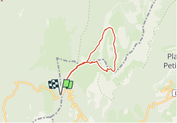

Length
6.4 km

Max alt
2036 m

Uphill gradient
664 m
Km-Effort
15.2 km

Min alt
1446 m

Downhill gradient
662 m
Boucle
Yes
Creation date :
2022-02-18 16:05:01.728
Updated on :
2022-02-18 16:05:53.311
3h27
Difficulty : Difficult

FREE GPS app for hiking
 SityTrail
IGN / Geographical institutes
SityTrail Plus
The world is yours!
About
Trail Walking of 6.4 km to be discovered at Auvergne-Rhône-Alpes, Isère, Saint-Pierre-de-Chartreuse. This trail is proposed by gerardmicheline.
Positioning
Country:
France
Region :
Auvergne-Rhône-Alpes
Department/Province :
Isère
Municipality :
Saint-Pierre-de-Chartreuse
Location:
Unknown
Start:(Dec)
Start:(UTM)
722393 ; 5020472 (31T) N.
Comments