


carqueiranne le mont des oiseaux

lauvernet
User
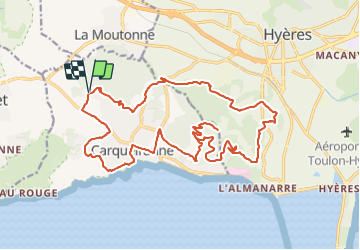

Length
26 km

Max alt
293 m

Uphill gradient
732 m
Km-Effort
36 km

Min alt
3 m

Downhill gradient
734 m
Boucle
Yes
Creation date :
2022-02-18 20:21:09.906
Updated on :
2022-02-18 20:22:06.051
2h29
Difficulty : Difficult
0m
Difficulty : Very easy

FREE GPS app for hiking
 SityTrail
IGN / Geographical institutes
SityTrail Plus
The world is yours!
About
Trail Mountain bike of 26 km to be discovered at Provence-Alpes-Côte d'Azur, Var, Carqueiranne. This trail is proposed by lauvernet.
Positioning
Country:
France
Region :
Provence-Alpes-Côte d'Azur
Department/Province :
Var
Municipality :
Carqueiranne
Location:
Unknown
Start:(Dec)
Start:(UTM)
260930 ; 4776717 (32T) N.
Comments