


Balcon de St-Mitre-les-Ramparts

Marc-Jacques
User

Length
12.3 km

Max alt
117 m

Uphill gradient
303 m
Km-Effort
16.3 km

Min alt
-1 m

Downhill gradient
302 m
Boucle
Yes
Creation date :
2022-02-17 09:18:45.604
Updated on :
2022-02-19 08:01:59.154
45h23
Difficulty : Medium

FREE GPS app for hiking
 SityTrail
IGN / Geographical institutes
SityTrail Plus
The world is yours!
About
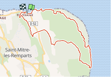
Trail Walking of 12.3 km to be discovered at Provence-Alpes-Côte d'Azur, Bouches-du-Rhône, Saint-Mitre-les-Remparts. This trail is proposed by Marc-Jacques.
Positioning
Country:
France
Region :
Provence-Alpes-Côte d'Azur
Department/Province :
Bouches-du-Rhône
Municipality :
Saint-Mitre-les-Remparts
Location:
Unknown
Start:(Dec)
Start:(UTM)
663359 ; 4814838 (31T) N.
Comments