


20220219fondry

michelelfn
User
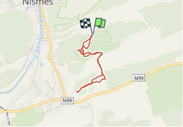

Length
2.9 km

Max alt
224 m

Uphill gradient
71 m
Km-Effort
3.9 km

Min alt
188 m

Downhill gradient
70 m
Boucle
Yes
Creation date :
2022-02-19 14:15:47.476
Updated on :
2022-02-19 15:44:47.45
1h28
Difficulty : Easy

FREE GPS app for hiking
 SityTrail
IGN / Geographical institutes
SityTrail Plus
The world is yours!
About
Trail Walking of 2.9 km to be discovered at Wallonia, Namur, Viroinval. This trail is proposed by michelelfn.
Positioning
Country:
Belgium
Region :
Wallonia
Department/Province :
Namur
Municipality :
Viroinval
Location:
Unknown
Start:(Dec)
Start:(UTM)
611492 ; 5547676 (31U) N.
Comments