Trail Walking Coutouvre - Coutouvre  - Photo
 xabert
xabert

User

© OpenStreetMap contributors
Length
Length
11.4 km
Max alt
Max alt
504 m
Uphill gradient
Uphill gradient
314 m
Km-Effort
Km-Effort  
15.5 km
Min alt
Min alt
362 m
Downhill gradient
Downhill gradient
311 m
Boucle
Boucle
Yes
Creation date :
2022-02-20 08:33:23.0
Updated on :
2022-02-20 11:44:13.775

(0 Reviews)

Walking
Walking
3h10
Difficulty : Difficult

Scan this QR Code to open this trail in the SityTrail application

FREE GPS app for hiking

Logo SityTrail SityTrail

IGN / Geographical institutes

Download SityTrail from the App Store Download SityTrail from Google Play

Logo SityTrail SityTrail World

The world is yours!

Download SityTrail from the App Store Download SityTrail from Google Play Download SityTrail on Huawei AppGallery

About

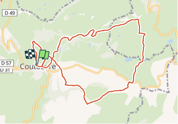
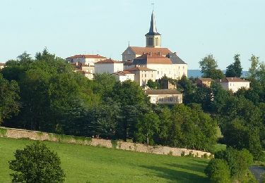
Trail Walking of 11.4 km to be discovered at Auvergne-Rhône-Alpes, Loire, Coutouvre. This trail is proposed by xabert.

Description

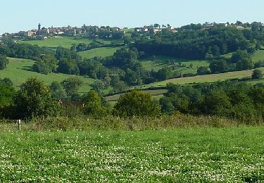
Bonne balade autour de Coutouvre - très vallonnée et sols boueux sur large partie .

Elevation profile

Positioning

Country:
France
Region :
Auvergne-Rhône-Alpes
Department/Province :
Loire
Municipality :
Coutouvre
Location:
Unknown
Start:(UTM)
593614 ; 5102974 (31T) N.

Trails nearby

Trail Walking Coutouvre -  Circuit des 2 chapelles - Coutouvre - Photo
Walking
tracegps

Walking

Difficult
(2)
Coutouvre, Auvergne-Rhône-Alpes, Loire, France
9.9 km | 13.4 km-effort
2h 30min
Yes
Trail Mountain bike Nandax - Rando la Fourchemolle (2014-VTT-40km) - Nandax-Ressins - Photo
Mountain bike
tracegps

Mountain bike

Difficult
Nandax, Auvergne-Rhône-Alpes, Loire, France
41 km | 53 km-effort
3h 30min
Yes
Trail Mountain bike Montagny - Randonnée La Montagnarde (2014-VTT-30km) - Montagny - Photo
Mountain bike
tracegps

Mountain bike

Difficult
Montagny, Auvergne-Rhône-Alpes, Loire, France
29 km | 40 km-effort
3h 0min
Yes
Trail Walking Montagny - Circuit N° 11 - L'Excursion Montagnarde - Montagny - Photo
Walking
tracegps

Walking

Very difficult
Montagny, Auvergne-Rhône-Alpes, Loire, France
12.9 km | 17.5 km-effort
3h 45min
Yes
Trail Mountain bike Nandax - EQUIVTT 2013 - Nandax-Ressins - Photo
Mountain bike
tracegps

Mountain bike

Difficult
(1)
Nandax, Auvergne-Rhône-Alpes, Loire, France
32 km | 42 km-effort
3h 0min
Yes
Trail Mountain bike Montagny - Randonnée La Montagnarde (2012-VTT-35km) - Montagny - Photo
Mountain bike
tracegps

Mountain bike

Difficult
Montagny, Auvergne-Rhône-Alpes, Loire, France
33 km | 44 km-effort
3h 0min
Yes
Trail Walking Coutouvre - Circuit de Coutouvre - 11km - Photo
Walking
tracegps

Walking

Medium
Coutouvre, Auvergne-Rhône-Alpes, Loire, France
11.4 km | 15.9 km-effort
2h 45min
Yes
Trail Walking Jarnosse - Jarnosse - Photo
Walking
Pierre Burthier

Walking

Difficult
Jarnosse, Auvergne-Rhône-Alpes, Loire, France
10.9 km | 14.8 km-effort
3h 22min
Yes
Trail Walking Jarnosse - Jarnosse R3-GRS Chauffailles-19122023 - Photo
Walking
Denys Cellard

Walking

Medium
Jarnosse, Auvergne-Rhône-Alpes, Loire, France
7.3 km | 10 km-effort
2h 15min
Yes


Close
My subscriptions