


Les 3 croix

Arnaud Stévenard
User
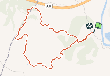

Length
7.4 km

Max alt
334 m

Uphill gradient
526 m
Km-Effort
14.4 km

Min alt
13 m

Downhill gradient
526 m
Boucle
Yes
Creation date :
2022-02-20 08:00:57.0
Updated on :
2022-02-20 15:54:49.208
7h52
Difficulty : Difficult

FREE GPS app for hiking
 SityTrail
IGN / Geographical institutes
SityTrail Plus
The world is yours!
About
Trail Walking of 7.4 km to be discovered at Provence-Alpes-Côte d'Azur, Var, Roquebrune-sur-Argens. This trail is proposed by Arnaud Stévenard.
Positioning
Country:
France
Region :
Provence-Alpes-Côte d'Azur
Department/Province :
Var
Municipality :
Roquebrune-sur-Argens
Location:
Unknown
Start:(Dec)
Start:(UTM)
306864 ; 4813975 (32T) N.
Comments