


signal de randon

lablaquiere
User
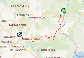

Length
9.7 km

Max alt
1549 m

Uphill gradient
139 m
Km-Effort
12.7 km

Min alt
1112 m

Downhill gradient
483 m
Boucle
No
Creation date :
2022-02-20 13:29:05.293
Updated on :
2022-02-20 16:30:04.903
2h22
Difficulty : Difficult

FREE GPS app for hiking
 SityTrail
IGN / Geographical institutes
SityTrail Plus
The world is yours!
About
Trail Walking of 9.7 km to be discovered at Occitania, Lozère, Monts-de-Randon. This trail is proposed by lablaquiere.
Positioning
Country:
France
Region :
Occitania
Department/Province :
Lozère
Municipality :
Monts-de-Randon
Location:
Estables
Start:(Dec)
Start:(UTM)
543023 ; 4946202 (31T) N.
Comments