Trail Mountain bike Beckenried - Bike32880 - Photo

Optez pour le retour à la nature GUIDE+
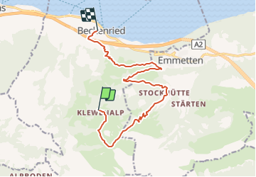
© OpenStreetMap contributors
Length
Length
13.2 km
Max alt
Max alt
1609 m
Uphill gradient
Uphill gradient
89 m
Km-Effort
Km-Effort  
18.2 km
Min alt
Min alt
449 m
Downhill gradient
Downhill gradient
1224 m
Boucle
Boucle
No
Creation date :
2014-12-10 00:00:00.0
Updated on :
2014-12-10 00:00:00.0

(0 Reviews)

Mountain bike
Mountain bike
--
Difficulty : Unknown

Scan this QR Code to open this trail in the SityTrail application

FREE GPS app for hiking

Logo SityTrail SityTrail

IGN / Geographical institutes

Download SityTrail from the App Store Download SityTrail from Google Play

Logo SityTrail SityTrail Plus

The world is yours!

Download SityTrail from the App Store Download SityTrail from Google Play Download SityTrail on Huawei AppGallery

About

Trail Mountain bike of 13.2 km to be discovered at Nidwalden, Unknown, Beckenried. This trail is proposed by My Switzerland.

Elevation profile

Points of interest

Point of interest Beckenried - Bergstation Klewenalp - Photo
My Switzerland
Point of interest Beckenried -  - Photo
My Switzerland
BECKENRIED 
Point of interest Beckenried -  - Photo
My Switzerland
BECKENRIED 
Point of interest Beckenried - Talstation Beckenried - Photo
My Switzerland

Positioning

Country:
Switzerland
Region :
Nidwalden
Department/Province :
Unknown
Municipality :
Beckenried
Location:
Unknown
Start:(UTM)
459884 ; 5198627 (32T) N.


Close
My subscriptions