


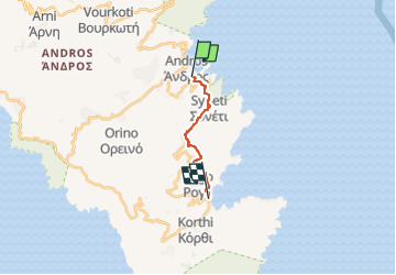
Andros Routes 3

SityTrail - itinéraires balisés pédestres
Tous les sentiers balisés d’Europe GUIDE+

Length
10.4 km

Max alt
476 m

Uphill gradient
578 m
Km-Effort
18.1 km

Min alt
7 m

Downhill gradient
581 m
Boucle
No

Signpost
Creation date :
2022-02-21 10:48:28.032
Updated on :
2022-03-09 00:19:53.726
4h07
Difficulty : Easy

FREE GPS app for hiking
 SityTrail
IGN / Geographical institutes
SityTrail Plus
The world is yours!
About
Trail On foot of 10.4 km to be discovered at Aegean, Andros Regional Unit. This trail is proposed by SityTrail - itinéraires balisés pédestres.
Description
Trail created by Andros Routes.
Symbol: red_rectangle
Website: https://www.androsroutes.gr/
Photos


Positioning
Country:
Greece
Region :
Aegean
Department/Province :
Andros Regional Unit
Municipality :
Unknown
Location:
Unknown
Start:(Dec)
Start:(UTM)
318751 ; 4189217 (35S) N.
Comments