


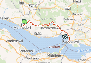
Männedorf-Rapperswil

My Switzerland
Optez pour le retour à la nature GUIDE+

Length
15.1 km

Max alt
630 m

Uphill gradient
372 m
Km-Effort
20 km

Min alt
407 m

Downhill gradient
368 m
Boucle
No
Creation date :
2014-12-10 00:00:00.0
Updated on :
2014-12-10 00:00:00.0
4h22
Difficulty : Unknown

FREE GPS app for hiking
 SityTrail
IGN / Geographical institutes
SityTrail Plus
The world is yours!
About
Trail Walking of 15.1 km to be discovered at Zurich, Bezirk Meilen, Männedorf. This trail is proposed by My Switzerland.
Positioning
Country:
Switzerland
Region :
Zurich
Department/Province :
Bezirk Meilen
Municipality :
Männedorf
Location:
Unknown
Start:(Dec)
Start:(UTM)
476491 ; 5233328 (32T) N.
Comments