


RIF-02-2022-1 du 20.02.2022

bene_dictus77
User
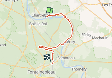

Length
23 km

Max alt
123 m

Uphill gradient
293 m
Km-Effort
26 km

Min alt
40 m

Downhill gradient
250 m
Boucle
No
Creation date :
2022-02-20 08:22:25.988
Updated on :
2022-02-21 18:20:04.066
7h06
Difficulty : Very easy

FREE GPS app for hiking
 SityTrail
IGN / Geographical institutes
SityTrail Plus
The world is yours!
About
Trail Walking of 23 km to be discovered at Ile-de-France, Seine-et-Marne, Chartrettes. This trail is proposed by bene_dictus77.
Description
de Bois Le Roi à Fontainebleau
Positioning
Country:
France
Region :
Ile-de-France
Department/Province :
Seine-et-Marne
Municipality :
Chartrettes
Location:
Unknown
Start:(Dec)
Start:(UTM)
478664 ; 5370250 (31U) N.
Comments