


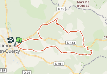
circuit de la fontaine de Malecargue

houbart
User


2h48
Difficulty : Difficult

FREE GPS app for hiking
 SityTrail
IGN / Geographical institutes
SityTrail Plus
The world is yours!
About
Trail Walking of 9.9 km to be discovered at Occitania, Lot, Limogne-en-Quercy. This trail is proposed by houbart.
Description
La fontaine de Malecargue avec sa pompe à chapelet a dans un passé récent assuré la survie des troupeaux grâce à son imposant abreuvoir. Situé en bordure du chemin de Saint Jacques de Compostelle elle constitue avec la fontaine de Buzou une trace remarquable du patrimoine des fontaines.


Positioning
Comments