


Éventé

Danielj
User

Length
11.5 km

Max alt
484 m

Uphill gradient
187 m
Km-Effort
14 km

Min alt
383 m

Downhill gradient
188 m
Boucle
Yes
Creation date :
2022-02-22 09:34:32.0
Updated on :
2022-02-22 13:19:37.432
3h17
Difficulty : Difficult

FREE GPS app for hiking
 SityTrail
IGN / Geographical institutes
SityTrail Plus
The world is yours!
About
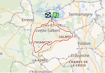
Trail Walking of 11.5 km to be discovered at Bourgogne-Franche-Comté, Territoire-de-Belfort, Évette-Salbert. This trail is proposed by Danielj.
Positioning
Country:
France
Region :
Bourgogne-Franche-Comté
Department/Province :
Territoire-de-Belfort
Municipality :
Évette-Salbert
Location:
Unknown
Start:(Dec)
Start:(UTM)
335127 ; 5283301 (32T) N.
Comments