


Montarcher Marols

psesjs
User
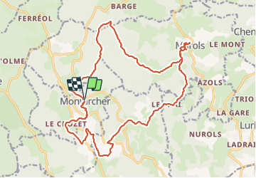

Length
22 km

Max alt
1180 m

Uphill gradient
719 m
Km-Effort
32 km

Min alt
825 m

Downhill gradient
725 m
Boucle
Yes
Creation date :
2022-02-22 08:17:42.531
Updated on :
2022-02-22 15:20:15.321
5h33
Difficulty : Very difficult

FREE GPS app for hiking
 SityTrail
IGN / Geographical institutes
SityTrail Plus
The world is yours!
About
Trail Walking of 22 km to be discovered at Auvergne-Rhône-Alpes, Loire, Montarcher. This trail is proposed by psesjs.
Positioning
Country:
France
Region :
Auvergne-Rhône-Alpes
Department/Province :
Loire
Municipality :
Montarcher
Location:
Unknown
Start:(Dec)
Start:(UTM)
577846 ; 5034487 (31T) N.
Comments