


peyrins

HAL26
User
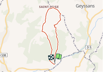

Length
6.6 km

Max alt
408 m

Uphill gradient
182 m
Km-Effort
9.1 km

Min alt
233 m

Downhill gradient
189 m
Boucle
Yes
Creation date :
2022-02-22 13:29:51.165
Updated on :
2022-02-22 17:57:37.392
1h37
Difficulty : Medium

FREE GPS app for hiking
 SityTrail
IGN / Geographical institutes
SityTrail Plus
The world is yours!
About
Trail Walking of 6.6 km to be discovered at Auvergne-Rhône-Alpes, Drôme, Peyrins. This trail is proposed by HAL26.
Positioning
Country:
France
Region :
Auvergne-Rhône-Alpes
Department/Province :
Drôme
Municipality :
Peyrins
Location:
Unknown
Start:(Dec)
Start:(UTM)
663315 ; 4995777 (31T) N.
Comments