


ocgif VTT mercredi 24 février 2022

marcagif
User

Length
46 km

Max alt
182 m

Uphill gradient
694 m
Km-Effort
55 km

Min alt
62 m

Downhill gradient
692 m
Boucle
Yes
Creation date :
2022-02-23 07:54:45.955
Updated on :
2022-02-24 10:23:04.844
3h13
Difficulty : Medium

FREE GPS app for hiking
 SityTrail
IGN / Geographical institutes
SityTrail Plus
The world is yours!
About
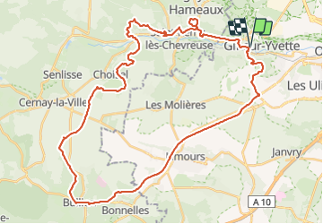
Trail Mountain bike of 46 km to be discovered at Ile-de-France, Essonne, Gif-sur-Yvette. This trail is proposed by marcagif.
Positioning
Country:
France
Region :
Ile-de-France
Department/Province :
Essonne
Municipality :
Gif-sur-Yvette
Location:
Unknown
Start:(Dec)
Start:(UTM)
435674 ; 5394584 (31U) N.
Comments