


02.06.2011.St Suliac.11 k 5 - 17h41m13

babeth35
User
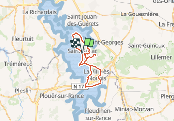

Length
23 km

Max alt
71 m

Uphill gradient
341 m
Km-Effort
28 km

Min alt
0 m

Downhill gradient
342 m
Boucle
Yes
Creation date :
2014-12-10 00:00:00.0
Updated on :
2022-02-24 16:48:42.847
3h49
Difficulty : Easy
--
Difficulty : Easy

FREE GPS app for hiking
 SityTrail
IGN / Geographical institutes
SityTrail Plus
The world is yours!
About
Trail On foot of 23 km to be discovered at Brittany, Ille-et-Vilaine, Saint-Suliac. This trail is proposed by babeth35.
Photos


Positioning
Country:
France
Region :
Brittany
Department/Province :
Ille-et-Vilaine
Municipality :
Saint-Suliac
Location:
Unknown
Start:(Dec)
Start:(UTM)
575754 ; 5379876 (30U) N.
Comments