


89.220 Petange - Circuit

ADL339
User
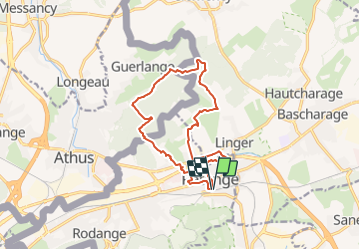

Length
13.2 km

Max alt
379 m

Uphill gradient
263 m
Km-Effort
16.7 km

Min alt
269 m

Downhill gradient
263 m
Boucle
Yes
Creation date :
2022-02-25 08:12:41.0
Updated on :
2022-02-25 08:12:42.303
3h46
Difficulty : Medium

FREE GPS app for hiking
 SityTrail
IGN / Geographical institutes
SityTrail Plus
The world is yours!
About
Trail Walking of 13.2 km to be discovered at Unknown, Canton Esch-sur-Alzette, Pétange. This trail is proposed by ADL339.
Positioning
Country:
Luxembourg
Region :
Unknown
Department/Province :
Canton Esch-sur-Alzette
Municipality :
Pétange
Location:
Pétange
Start:(Dec)
Start:(UTM)
708212 ; 5493059 (31U) N.
Comments