


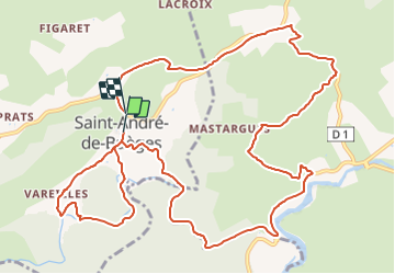
Saint André de Buèges

grageot
User

Length
15.4 km

Max alt
222 m

Uphill gradient
275 m
Km-Effort
19.1 km

Min alt
111 m

Downhill gradient
277 m
Boucle
No
Creation date :
2022-02-25 09:30:46.436
Updated on :
2022-02-25 09:32:24.365
4h20
Difficulty : Very difficult

FREE GPS app for hiking
 SityTrail
IGN / Geographical institutes
SityTrail Plus
The world is yours!
About
Trail Walking of 15.4 km to be discovered at Occitania, Hérault, Saint-André-de-Buèges. This trail is proposed by grageot.
Positioning
Country:
France
Region :
Occitania
Department/Province :
Hérault
Municipality :
Saint-André-de-Buèges
Location:
Unknown
Start:(Dec)
Start:(UTM)
553284 ; 4855179 (31T) N.
Comments