


Plaine des Rompudes Nevissac

pb07
User
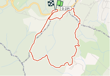

Length
5.4 km

Max alt
424 m

Uphill gradient
164 m
Km-Effort
7.5 km

Min alt
287 m

Downhill gradient
164 m
Boucle
Yes
Creation date :
2022-02-25 13:01:55.029
Updated on :
2022-02-25 15:20:36.483
2h18
Difficulty : Medium

FREE GPS app for hiking
 SityTrail
IGN / Geographical institutes
SityTrail Plus
The world is yours!
About
Trail Walking of 5.4 km to be discovered at Auvergne-Rhône-Alpes, Ardèche, Mercuer. This trail is proposed by pb07.
Positioning
Country:
France
Region :
Auvergne-Rhône-Alpes
Department/Province :
Ardèche
Municipality :
Mercuer
Location:
Unknown
Start:(Dec)
Start:(UTM)
607725 ; 4941352 (31T) N.
Comments