


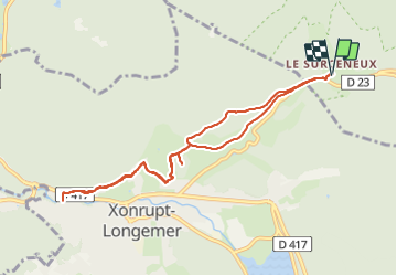
SURCENEUX SAUT DES CUVES AR

surceneux
User

Length
8.7 km

Max alt
865 m

Uphill gradient
253 m
Km-Effort
12.1 km

Min alt
700 m

Downhill gradient
253 m
Boucle
Yes
Creation date :
2022-02-25 15:52:13.827
Updated on :
2022-02-25 18:33:32.307
1h50
Difficulty : Easy

FREE GPS app for hiking
 SityTrail
IGN / Geographical institutes
SityTrail Plus
The world is yours!
About
Trail Walking of 8.7 km to be discovered at Grand Est, Vosges, Ban-sur-Meurthe-Clefcy. This trail is proposed by surceneux.
Description
BEHEUILLE ROCHE DU PAGE SAUT DES CUVES ANNEAU BLEU AR
Positioning
Country:
France
Region :
Grand Est
Department/Province :
Vosges
Municipality :
Ban-sur-Meurthe-Clefcy
Location:
Unknown
Start:(Dec)
Start:(UTM)
347841 ; 5329049 (32U) N.
Comments