


GOUVIEUX SENLIS

Marc ROUSSELOT
User
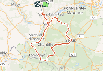

Length
66 km

Max alt
127 m

Uphill gradient
573 m
Km-Effort
73 km

Min alt
23 m

Downhill gradient
571 m
Boucle
Yes
Creation date :
2022-02-27 07:26:23.277
Updated on :
2022-02-27 12:49:31.322
4h33
Difficulty : Very difficult

FREE GPS app for hiking
 SityTrail
IGN / Geographical institutes
SityTrail Plus
The world is yours!
About
Trail Road bike of 66 km to be discovered at Hauts-de-France, Oise, Laigneville. This trail is proposed by Marc ROUSSELOT.
Positioning
Country:
France
Region :
Hauts-de-France
Department/Province :
Oise
Municipality :
Laigneville
Location:
Unknown
Start:(Dec)
Start:(UTM)
459731 ; 5461045 (31U) N.
Comments