


villemagne

Mascart
User

Length
27 km

Max alt
422 m

Uphill gradient
629 m
Km-Effort
36 km

Min alt
115 m

Downhill gradient
717 m
Boucle
No
Creation date :
2022-02-27 13:34:07.915
Updated on :
2022-02-27 17:48:28.644
3h45
Difficulty : Medium

FREE GPS app for hiking
 SityTrail
IGN / Geographical institutes
SityTrail Plus
The world is yours!
About
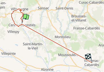
Trail Walking of 27 km to be discovered at Occitania, Aude, Cenne-Monestiés. This trail is proposed by Mascart.
Description
départ de Cennes monestier
Positioning
Country:
France
Region :
Occitania
Department/Province :
Aude
Municipality :
Cenne-Monestiés
Location:
Unknown
Start:(Dec)
Start:(UTM)
428488 ; 4798314 (31T) N.
Comments