


Hoch über dem Blenio-Tal

My Switzerland
Optez pour le retour à la nature GUIDE+
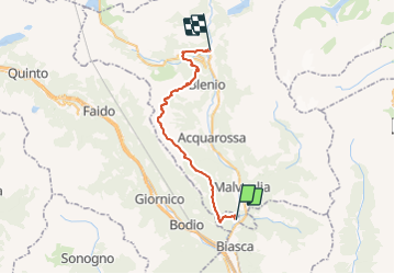

Length
32 km

Max alt
1975 m

Uphill gradient
2183 m
Km-Effort
59 km

Min alt
363 m

Downhill gradient
1647 m
Boucle
No
Creation date :
2014-12-10 00:00:00.0
Updated on :
2014-12-10 00:00:00.0
--
Difficulty : Unknown

FREE GPS app for hiking
 SityTrail
IGN / Geographical institutes
SityTrail Plus
The world is yours!
About
Trail Walking of 32 km to be discovered at Ticino, Distretto di Riviera, Biasca. This trail is proposed by My Switzerland.
Positioning
Country:
Switzerland
Region :
Ticino
Department/Province :
Distretto di Riviera
Municipality :
Biasca
Location:
Unknown
Start:(Dec)
Start:(UTM)
497886 ; 5136703 (32T) N.
Comments