


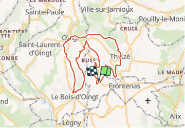
Moiré (18 km - D. 610 m) CV

Thomasdanielle
User

Length
18.2 km

Max alt
585 m

Uphill gradient
610 m
Km-Effort
26 km

Min alt
354 m

Downhill gradient
605 m
Boucle
Yes
Creation date :
2022-02-28 08:15:01.0
Updated on :
2022-03-05 09:30:21.376
4h55
Difficulty : Very difficult

FREE GPS app for hiking
 SityTrail
IGN / Geographical institutes
SityTrail Plus
The world is yours!
About
Trail Walking of 18.2 km to be discovered at Auvergne-Rhône-Alpes, Rhône, Moiré. This trail is proposed by Thomasdanielle.
Description
D/A : Parking du cimetière
Positioning
Country:
France
Region :
Auvergne-Rhône-Alpes
Department/Province :
Rhône
Municipality :
Moiré
Location:
Unknown
Start:(Dec)
Start:(UTM)
624207 ; 5087253 (31T) N.
Comments