


mellecey

mcterret
User
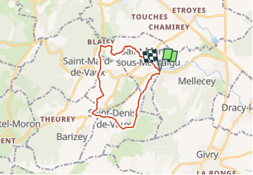

Length
11 km

Max alt
405 m

Uphill gradient
354 m
Km-Effort
15.6 km

Min alt
213 m

Downhill gradient
347 m
Boucle
Yes
Creation date :
2022-02-28 12:47:28.306
Updated on :
2022-02-28 16:01:39.026
3h13
Difficulty : Easy

FREE GPS app for hiking
 SityTrail
IGN / Geographical institutes
SityTrail Plus
The world is yours!
About
Trail Walking of 11 km to be discovered at Bourgogne-Franche-Comté, Saône-et-Loire, Mellecey. This trail is proposed by mcterret.
Positioning
Country:
France
Region :
Bourgogne-Franche-Comté
Department/Province :
Saône-et-Loire
Municipality :
Mellecey
Location:
Unknown
Start:(Dec)
Start:(UTM)
631252 ; 5185600 (31T) N.
Comments