


Besançon 1

yvesconnes
User
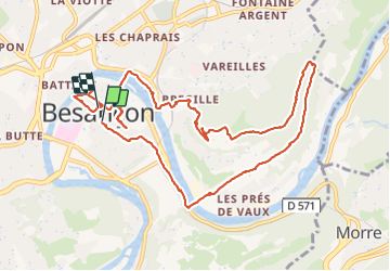

Length
11.7 km

Max alt
437 m

Uphill gradient
288 m
Km-Effort
15.5 km

Min alt
241 m

Downhill gradient
289 m
Boucle
Yes
Creation date :
2022-02-28 13:08:34.671
Updated on :
2022-02-28 18:31:29.524
4h37
Difficulty : Easy

FREE GPS app for hiking
 SityTrail
IGN / Geographical institutes
SityTrail Plus
The world is yours!
About
Trail Walking of 11.7 km to be discovered at Bourgogne-Franche-Comté, Doubs, Besançon. This trail is proposed by yvesconnes.
Positioning
Country:
France
Region :
Bourgogne-Franche-Comté
Department/Province :
Doubs
Municipality :
Besançon
Location:
Unknown
Start:(Dec)
Start:(UTM)
274843 ; 5235802 (32T) N.
Comments