


Pierre Chauve depuis le Col de Tourniol

McTracy004
User
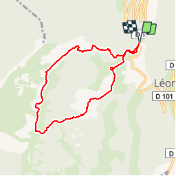

Length
7.9 km

Max alt
1299 m

Uphill gradient
330 m
Km-Effort
12.3 km

Min alt
1034 m

Downhill gradient
333 m
Boucle
Yes
Creation date :
2014-12-10 00:00:00.0
Updated on :
2014-12-10 00:00:00.0
2h52
Difficulty : Easy

FREE GPS app for hiking
 SityTrail
IGN / Geographical institutes
SityTrail Plus
The world is yours!
About
Trail Walking of 7.9 km to be discovered at Auvergne-Rhône-Alpes, Drôme, Léoncel. This trail is proposed by McTracy004.
Description
Balade aux alentours de Léoncel, vue sur le Vercors et les vallées du Rhône et de l'Isère
Positioning
Country:
France
Region :
Auvergne-Rhône-Alpes
Department/Province :
Drôme
Municipality :
Léoncel
Location:
Unknown
Start:(Dec)
Start:(UTM)
672393 ; 4976190 (31T) N.
Comments
très intéressant surtout par beau temps !