


Moto Cajarc - Conques

Levillefranchois
User
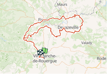

Length
213 km

Max alt
610 m

Uphill gradient
3621 m
Km-Effort
261 km

Min alt
148 m

Downhill gradient
3693 m
Boucle
No
Creation date :
2022-02-27 11:59:28.0
Updated on :
2022-03-04 12:59:12.157
5h41
Difficulty : Easy

FREE GPS app for hiking
 SityTrail
IGN / Geographical institutes
SityTrail Plus
The world is yours!
About
Trail Motorbike of 213 km to be discovered at Occitania, Aveyron, Villefranche-de-Rouergue. This trail is proposed by Levillefranchois.
Positioning
Country:
France
Region :
Occitania
Department/Province :
Aveyron
Municipality :
Villefranche-de-Rouergue
Location:
Unknown
Start:(Dec)
Start:(UTM)
420078 ; 4912296 (31T) N.
Comments