


Saint Antonin Entrecasteaux le premier mars 2022

clintest
User
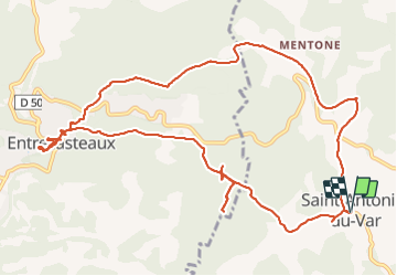

Length
14.7 km

Max alt
308 m

Uphill gradient
415 m
Km-Effort
20 km

Min alt
148 m

Downhill gradient
415 m
Boucle
Yes
Creation date :
2022-03-01 08:22:05.206
Updated on :
2022-03-01 13:24:35.949
4h05
Difficulty : Very difficult

FREE GPS app for hiking
 SityTrail
IGN / Geographical institutes
SityTrail Plus
The world is yours!
About
Trail Walking of 14.7 km to be discovered at Provence-Alpes-Côte d'Azur, Var, Saint-Antonin-du-Var. This trail is proposed by clintest.
Positioning
Country:
France
Region :
Provence-Alpes-Côte d'Azur
Department/Province :
Var
Municipality :
Saint-Antonin-du-Var
Location:
Unknown
Start:(Dec)
Start:(UTM)
280804 ; 4820639 (32T) N.
Comments