


sortie du 1-03-2022

Didier-114
User
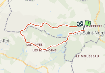

Length
7.3 km

Max alt
182 m

Uphill gradient
136 m
Km-Effort
9.2 km

Min alt
112 m

Downhill gradient
141 m
Boucle
Yes
Creation date :
2022-03-01 12:55:20.852
Updated on :
2022-03-01 15:26:38.028
2h30
Difficulty : Easy

FREE GPS app for hiking
 SityTrail
IGN / Geographical institutes
SityTrail Plus
The world is yours!
About
Trail Walking of 7.3 km to be discovered at Ile-de-France, Yvelines, Lévis-Saint-Nom. This trail is proposed by Didier-114.
Positioning
Country:
France
Region :
Ile-de-France
Department/Province :
Yvelines
Municipality :
Lévis-Saint-Nom
Location:
Unknown
Start:(Dec)
Start:(UTM)
422700 ; 5397052 (31U) N.
Comments