


RAON la pierre d'appel juin 2014

DENOMME
User

Length
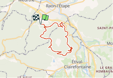
15.4 km

Max alt
582 m

Uphill gradient
565 m
Km-Effort
23 km

Min alt
331 m

Downhill gradient
565 m
Boucle
Yes
Creation date :
2014-12-10 00:00:00.0
Updated on :
2014-12-10 00:00:00.0
3h12
Difficulty : Difficult

FREE GPS app for hiking
 SityTrail
IGN / Geographical institutes
SityTrail Plus
The world is yours!
About
Trail Mountain bike of 15.4 km to be discovered at Grand Est, Vosges, Raon-l'Étape. This trail is proposed by DENOMME.
Positioning
Country:
France
Region :
Grand Est
Department/Province :
Vosges
Municipality :
Raon-l'Étape
Location:
Unknown
Start:(Dec)
Start:(UTM)
339003 ; 5362306 (32U) N.
Comments