


Plan d'Aups-02-03-22

Christiancordin
User

Length
16.6 km

Max alt
803 m

Uphill gradient
799 m
Km-Effort
27 km

Min alt
265 m

Downhill gradient
803 m
Boucle
Yes
Creation date :
2022-03-02 08:22:46.971
Updated on :
2022-03-07 17:14:36.125
5h33
Difficulty : Medium

FREE GPS app for hiking
 SityTrail
IGN / Geographical institutes
SityTrail Plus
The world is yours!
About
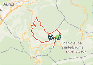
Trail Walking of 16.6 km to be discovered at Provence-Alpes-Côte d'Azur, Var, Plan-d'Aups-Sainte-Baume. This trail is proposed by Christiancordin.
Description
tour Cauvin-l 'Adret-GR MPM-pont des Encanaux-glacière-les Infernets-la Coutronne.
Photos


Positioning
Country:
France
Region :
Provence-Alpes-Côte d'Azur
Department/Province :
Var
Municipality :
Plan-d'Aups-Sainte-Baume
Location:
Unknown
Start:(Dec)
Start:(UTM)
718161 ; 4801130 (31T) N.
Comments