


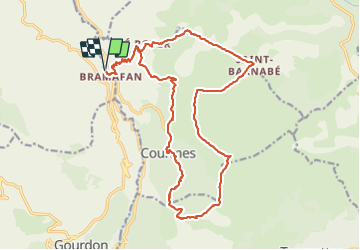
Courmes

ETMU5496
User

Length
24 km

Max alt
1263 m

Uphill gradient
1335 m
Km-Effort
42 km

Min alt
476 m

Downhill gradient
1335 m
Boucle
Yes
Creation date :
2022-03-02 07:53:18.0
Updated on :
2022-03-24 14:45:13.379
6h14
Difficulty : Difficult

FREE GPS app for hiking
 SityTrail
IGN / Geographical institutes
SityTrail Plus
The world is yours!
About
Trail Walking of 24 km to be discovered at Provence-Alpes-Côte d'Azur, Maritime Alps, Courmes. This trail is proposed by ETMU5496.
Description
Puy de Tourettes et col de Courmettes
Photos


32 photos in total. Please click on a photo to see them all in the gallery.
Positioning
Country:
France
Region :
Provence-Alpes-Côte d'Azur
Department/Province :
Maritime Alps
Municipality :
Courmes
Location:
Unknown
Start:(Dec)
Start:(UTM)
338008 ; 4847516 (32T) N.
Comments