


Rando bab2

pe78
User
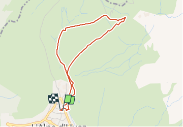

Length
4.1 km

Max alt
2066 m

Uphill gradient
221 m
Km-Effort
7.1 km

Min alt
1841 m

Downhill gradient
221 m
Boucle
Yes
Creation date :
2022-03-03 08:42:17.0
Updated on :
2022-03-03 11:08:18.307
2h25
Difficulty : Unknown

FREE GPS app for hiking
 SityTrail
IGN / Geographical institutes
SityTrail Plus
The world is yours!
About
Trail Touring skiing of 4.1 km to be discovered at Auvergne-Rhône-Alpes, Isère, Huez. This trail is proposed by pe78.
Positioning
Country:
France
Region :
Auvergne-Rhône-Alpes
Department/Province :
Isère
Municipality :
Huez
Location:
Unknown
Start:(Dec)
Start:(UTM)
269503 ; 4997604 (32T) N.
Comments